The Antarctic Ice Sheets (AIS) ECV project develops methods for producing long-term and reliable climate data records of Antarctica from satellite observations and distributes these records for use by the wider scientific community.
To do this, we make use of measurements acquired by ESA and other space agency satellites dating back to the early 1990s. The key parameters we focus on are measurements of the AIS Surface Elevation Change (SEC), Ice Velocity (IV), Grounding Line Location (GLL), and Gravimetric Mass Balance (GMB). We also provide scientific leadership for the Ice Sheet Mass Balance Inter-comparison Exercise (IMBIE), a community effort to reconcile satellite estimates of the sea level contribution due to Antarctica and Greenland.
Our datasets have helped to improve our understanding of historical and present-day change in Antarctica, to assess the skill of the IPCC’s climate models, and to improve the accuracy of climate projections.
Observations from space provide unique information about the climate system and climate change. It is increasingly clear that the observations are critical, and a coordinated effort is needed to ensure that long and reliable records are available and preserved. To address this need, the European Space Agency (ESA) has initiated the Climate Change Initiative to improve data products related to climate from long-term monitoring from space and to make these products available for all. The Global Climate Observation System (GCOS) has identified a list of Essential Climate Variables (ECVs), essential factors in the climate system. The ESA Climate Change Initiative (CCI) program has initiated programs devoted to 13 of these ECVs, one of which is ice sheets.
The state of the ice sheets is thought to be a major factor determining the pace of sea-level change. The goal of the ice_sheets_cci project is to set up a long-term and reliable production of a set of key parameters from ice sheets derived from available and future satellite observations. The selected key parameters are:
- Surface Elevation Change (SEC)
- Ice Velocity (IV)
- Grounding Line Location (GLL)
- Grounding Line Migration (GLM)
- Gravimetric Mass Balance (GMB)
- Ice Shelves CoastLine (ISCL)
- Calving Front Location (CFL) - not in production anymore.
The project focuses on the Antarctic ice sheet, including its outlet glaciers. Similar methods are implemented for the Greenland Ice Sheet (GIS).
The Need for Ice Sheet Data from Satellites
There is a global interest in understanding the dynamics of ice sheets and their response to climate change. This need has emerged from a need to understand the consequences of present and future changes of ice sheet mass in order to predict their contribution to the global and regional sea level change (when the ice sheets melt, sea level will drop in the vicinity of the ice sheets). One of the uncertainties in predicting future sea level is that the ice sheet flow models have not yet been developed at a sufficient level of detail to take the effects of fast-flowing ice streams into account. Furthermore, the physical processes at the base of an ice sheet and their relation to basal hydrology have not yet been fully addressed and implemented into models. The issue of basal conditions and their relation to fast-flowing ice streams is a critical point in understanding the ice sheet response to global warming.
Numerical models of the ice sheet are inherently complex. Model simulations require large computer resources, and the capacity of the computing systems implies constraints on the possible space and time resolution. This leads to the following situation:
- Large-scale ice sheet models are presently running on a lower resolution than available satellite data, e.g. surface elevation and velocity. Thus, they are not using the full capacity of satellite-based data in validations. These models generally need long time series to understand the effect of large-scale changes in climate and precipitation.
- To understand the processes controlling changes in ice flow and outlet glaciers, it is necessary to have access to high-resolution observations. Recently, new higher-order models, sometimes nested in lower-order models, have been developed to address this issue.
The ice sheet modelling community is generally a diverse and scattered community working with various models of different complexity, different datasets, different resolutions, with a focus on different goals. Ice flow modellers have been working independently with individually developed models, but in recent years, community ice flow models have been developed, and research groups are forming around these models. A number of these models are being coupled to climate models, mostly offline, but progress is being made in fully coupled climate and ice sheet model systems. The purpose of these coupled modelling efforts has mainly been to investigate the evolution of the ice sheets in the past or into the future, in particular to understand the contribution to the global sea level, and secondarily to include feedbacks from ice sheets in coupled climate models.
The international research community is relatively unorganised in regard to a formalised program of long-term monitoring of the Greenland Ice Sheet (GIS) changes. In spite of the immediate interest in GIS mass changes, the reporting of such changes is mainly found in scientific publications, but a few systematic monitoring programs are formalised.
Users of the Ice Sheets Data
Users of the ice_sheets_cci data products can generally be divided into the following groups:
- Ice sheet modellers who are using the ECV parameters to validate and/or initialise their models, e.g. comparing modelled and observed SEC, CFL or GLL, or using the ECV parameters to constrain model parameters, e.g. constrain basal drag and ice viscosity by fitting modelled and observed IV.
- Remote sensing scientists are deriving volume and mass changes from satellite observations.
- Surface mass balance modellers, who are interpreting satellite-observed volume and mass changes, e.g. deriving mass change from observed volume changes by using firn densification models, or comparing observed mass loss with estimates from surface mass balance models based on climate models and observations.
- Climate and Ocean modellers, who are interested in the ice sheet component of the climate system and its interactions with other parts of the climate system, e.g. freshwater fluxes from ice sheet on shorter timescales or orographic forcing of wind patterns on longer timescales.
- Authorities and organisations who are interested in monitoring the ice sheets for political or practical decisions, for example, hydro-power plant planning and maintenance, and information on iceberg production from calving glaciers, are of specific interest to future oil- and gas exploration off Greenland.
The direct users of the ice_sheets_cci data products are thus a relatively broad group covering several scientific communities. They are working with different approaches and at different levels. However, for all groups, it is often a significant problem to collect relevant data from various sources and to transform them into a standard format.
This section provides access to various datasets published by the Antarctic Ice Sheet ECV project. Samples of the project's datasets are also available on the ESA Climate Office Open Data Portal.
Surface elevation changes
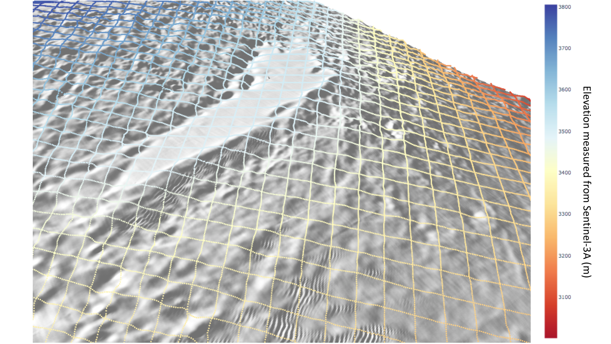
Surface elevation changes (SECs) of an ice sheet are directly linked to the atmospheric forcing and hence climate changes. The SEC reflects the vertical component of ice sheet mass balance. SEC is derived from satellite radar altimetry data, and therefore, the product is the elevation change of the reflecting surface rather than the snow surface.
Thanks to a succession of ESA satellite missions starting with ERS-1 in 1992 and continuing with CryoSat-2 and the Sentinel-3 missions, satellite altimetry provides the longest unbroken record of ice sheet mass balance from all geodetic techniques. Altimeter measurements of elevation change are extremely precise because they require only modest adjustments to account for sensor drift, changes in the satellite attitude, atmospheric attenuation, and movements of Earth's surface.
The Antarctic_Ice_Sheet_cci+ project will produce a continuous monthly time series of surface elevation change measured using over 28 years of radar altimetry satellites, including ERS-1, ERS-2, ENVISAT, CryoSat-2, Sentinel-3A and Sentinel-3B.
SEC products are hosted by CPOM: http://www.cpom.ucl.ac.uk/csopr/icesheets3
Ice Velocity
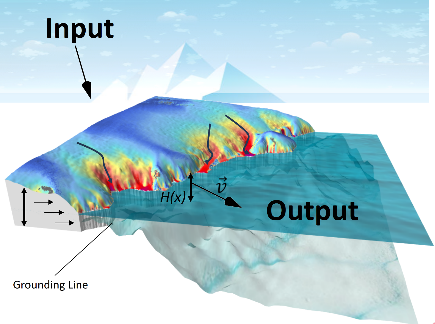
There is ample evidence indicating ongoing large and rapid changes in the Antarctic Ice Sheet, including the break-up of several ice shelves, glacier acceleration, and thinning and retreating grounding lines. The changes led to an increased ice discharge and contributed to sea level rise. Mapping ice sheet velocity (IV) and temporal changes in flow velocity provide key information for investigating the dynamic response of glaciers and ice sheets to changing boundary environmental conditions.
In the Antarctic Ice Sheet CCI project, SAR images acquired by the Sentinel-1 mission are used to derive ice flow velocity in Antarctica. Sentinel-1 has provided the opportunity to derive the ice flow velocity of key ice streams and outlet glaciers in Antarctica on a regular basis. The continuous coverage currently includes most of the Antarctic Ice Sheet margin, allowing for the retrieval of dense time series of ice flow for major Antarctic outlet glaciers previously only seldom observed.
In the current phase of the project, the system for IV retrieval will be further adapted and improved to accommodate new user requirements, increase data coverage and temporal resolution, and prepare for upcoming new SAR satellite missions (e.g. ROSE-L, NISAR).
We also plan to exploit the existing archive of ice velocity data and study the feasibility of a new ECV product on ice velocity change (IVC), detailing the spatial distribution of changes in ice flow rate over specified time intervals. IVC is a fundamental ice sheet parameter which is key to detecting and investigating dynamic instabilities and to identifying temporal fluctuations and long-term trends, thereby improving future predictions of ice flow in response to a changing climate.
IV products are provided on ENVEO CryoPortal and CEDA.
Grounding Line Location
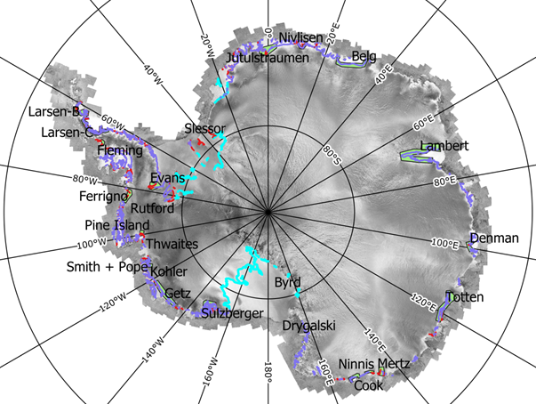
The location of the transition where the ice resting on bedrock detaches and becomes a floating ice shelf is a critical parameter needed for calculations of the ice sheet mass budget, as well as for modelling ice-ocean interactions, ice sheet dynamics, subglacial melt and oceanic tides. Due to its importance, the grounding line position is one of the key parameters of the ice sheets, which have been derived from satellite observations within the project.
The retrieval of the grounding line position is based on the influence of the ocean tides on the floating ice, which rests in hydrostatic equilibrium. Due to the fact that this tidal rise is absent on the grounded part of the glacier, a vertical deformation appears in the transition area.
The InSAR double differencing method (DInSAR) has been identified to be one of the most accurate techniques for locating the vertical tidal deformation of the ice sheet. At least two pairs of coherent repeat pass data sets must be combined in order to remove the common velocity component, revealing the vertical component due to tidal motion. In practice, the major limiting factor of this technique is the availability of data sets with sufficiently high InSAR coherence. Physical phenomena such as snow accumulation, drift or melting may significantly change the surface properties between the satellite passes and thus the backscatter behaviour, which can lead to loss of phase coherence in the interferograms.
The Antarctic_Ice_Sheet_cci+ project will continue the generation of GLL from recent Sentinel-1 constellation acquisitions on selected key glaciers, thus extending the temporal extension of GLL datasets.
GLL products are provided on ENVEO CryoPortal: http://cryoportal.enveo.at/. Access to product downloads requires registration and login. There are different user levels (anonymous, external, partner & staff) that determine the permissions for reading and accessing the data.
Grounding Line Migration
The short-term variation of the grounding line position will complement the time stamped Grounding Line Location (GLL) products by adding information on the extent of the grounding zone (the area in which the ice shelf repeatedly rests on the ocean bed).The aim of the Grounding Line Migration (GLM) product is to provide the short-term temporal variations of the grounding line position within the grounding zone but also separate this short-term position change from a long-term climatic induced position change that causes a relocation of the grounding zone. This new product is based on time series of GLL products and is currently under development.
Gravimetric Mass Balance
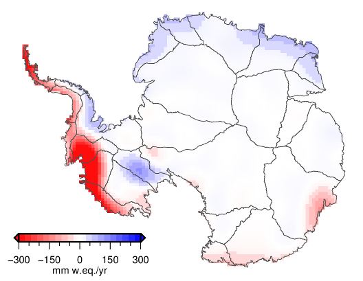
The Gravimetric Mass Balance (GMB) products are based on the GRACE (Gravity Recovery and Climate Experiment) and GRACE-FO (GRACE-Follow-On) satellite missions and respond to the high priority for mass balance parameters identified in the user survey. The GMB products have the advantage of their direct sensitivity to change in the total ice sheet mass (rather than geometry changes), including fluctuations in snow and ice on an approximately monthly time resolution, though with intrinsic limits in spatial resolution. Results from GRACE and GRACE-FO are available for the periods 2002-04 to 2017-06 and 2018-06 to present, respectively. For the 11-months gap between the two missions, GMB time series are interpolated by utilizing surface mass balance modeling results on short-term mass variations.
Two GMB products are provided: The GMB Basin Product consists of time series of monthly mass changes for individual drainage basins as well as aggregations to the East Antarctic Ice Sheet, the West Antarctic Ice Sheet, the Antarctic Peninsula, and the entire Antarctic Ice Sheet. The GMB Gridded Product provides gridded mass changes over the entire ice sheet. The GMB Basin Product is provided in ASCII format, while the gridded product is available in various formats, such as ASCII, netCDF and GeoTiff. GMB products are hosted by TU Dresden: https://data1.geo.tu-dresden.de/ais_gmb/. User-friendly functionalities allow users to interactively browse and explore both the GMB basin and the GMB gridded product. Mass change time series for individual drainage basins can be displayed by selecting the basin of interest from a map. The time series plot allows us to zoom to a certain period and to query values for a specific monthly solution. The plot can be saved in raster (png) and vector (SVG) formats. An animation of the monthly grid series is available to visualise the GMB gridded product. By selecting a particular month from the plot of the mass change time series for the entire AIS, the corresponding monthly grid is displayed.
Partitioned Gravimetric Mass Balance
Mass changes represented by the GMB product represent the sum of two fundamentally different effects: Effects of changing ice-flow dynamics are controlled by ice-ocean interaction, they are predominantly long-term (decadal and longer) and affect the mass of the whole ice column. In contrast, the effects of variations in surface mass balance (SMB) are controlled by ice-atmosphere interaction. They affect the firn layer and are predominantly short-term, although they may include long-term trends.
The GMB products will be supplemented by Partitioned GMB Products (GMB-P). They will represent a partitioning of the overall mass change into: GMB-P-S: mass balance due to SMB fluctuations around a long-term mean; and GMB-P-D (= GMB minus GMB-P-S): Dynamic and long-term mass balance. This partitioning will utilize modelled SMB fluctuations based on regional atmospheric climate models.
GMB-P will be provided in the same formats as the original GMB Products, that is, as GMB-P Basin Products and GMB-P-Gridded products.
Ice Shelves CoastLine
Antarctic Ice Shelves exhibit dynamic and sometimes unexpected daily activity, making the delineation of their coastlines (ISCLs) important to examine the health of the ice shelf and monitor calving. Previous solutions relied only on Radar data, but these solutions exhibit problems in differentiating between the ice shelf and sea ice. This project addresses this problem by developing a deep learning-based method that fuses radar (Sentinel-1) and altimetry (CS2) data to delineate ice shelf coastlines more accurately.The feasibility study focuses on delineating the ISCL between 2018-2022 for Larsen-C, Ronne, and Filchner. Our model significantly improves on the original delineations in fidelity and resolution, even though it used model-created labels from another work done by the DLR called Icelines. It provides monthly delineations of the chosen ice shelves with the native resolution of the Sentinel-1 Extra-Wide (EW) swath image. It anchors the detections and filters them using the CS2 altimetry data, which offers highly accurate elevation measurements that pinpoint precisely where the ice shelf starts and overcome the confusion with sea ice.ISCL lines in the AIS project are provided by S&T Norway and provide a framework for further investigations on how to fuse SAR and altimetry together to create more accurate ice tracking parameters.
Ice Discharge and IOM Mass Balance
Antarctic Ice Shelves exhibit dynamic and sometimes unexpected daily activity, making the delineation of their coastlines (ISCLs) important to examine the health of the ice shelf and monitor calving. Previous solutions relied only on Radar data, but these solutions exhibit problems in differentiating between the ice shelf and sea ice. This project addresses this problem by developing a deep learning-based method that fuses radar (Sentinel-1) and altimetry (CS2) data to delineate ice shelf coastlines more accurately.The feasibility study focuses on delineating the ISCL between 2018-2022 for Larsen-C, Ronne, and Filchner. Our model significantly improves on the original delineations in fidelity and resolution, even though it used model-created labels from another work done by the DLR called Icelines. It provides monthly delineations of the chosen ice shelves with the native resolution of the Sentinel-1 Extra-Wide (EW) swath image. It anchors the detections and filters them using the CS2 altimetry data, which offers highly accurate elevation measurements that pinpoint precisely where the ice shelf starts and overcome the confusion with sea ice.ISCL lines in the AIS project are provided by S&T Norway and provide a framework for further investigations on how to fuse SAR and altimetry together to create more accurate ice tracking parameters.
The Antarctic_Ice_Sheet_cci+ project team comprises eight scientific and industrial partners from the UK, Denmark, Norway, Austria and Germany.
The team is organised as follows:
- Project Lead and Scientific Lead - Northumbria University (NU). The Science Lead is Prof. Andrew Shepherd.
- Technical Project Management - Science And Technology AS (S&T).
- Climate Research Group - led by Prof. Tony Payne of the University of Bristol.
Northumbria University (NU) is the project leader, responsible for the scientific coordination of the project, relations with ESA and communicating about the project to relevant scientific communities. NU has extensive experience with research projects concerning the Antarctic ice sheet and with the processing of satellite data sets. Prof. Andrew Shepherd (UL) is a Professor of Earth Observation at Northumbria University, Director of the UK Centre for Polar Observation and Modelling, and Principal Scientific Advisor to the CryoSat-2 mission. Prof. Shepherd has over 20 years of experience in the use of Earth Observation data sets, including the use of satellite radar altimetry and satellite radar interferometry to study the polar regions. He has also led numerous field campaigns to calibrate and validate satellite observations, including in the Arctic and Antarctic regions. Furthermore, he is the author of a body of research that is widely reported in the media.
Science And Technology AS (S&T) is responsible for the Antarctic Ice Sheet CCI+ technical project management.
DLR's (Deutsches Zentrum für Luft- und Raumfahrt) IMF (Remote Sensing Technology Institute) is participating in the scientific algorithm development and product generation for the GLL parameter. DLR IMF is focused on sensor-specific algorithms and software. The SAR Signal Processing Department at IMF, involved in this project, develops operational software for interferometric SAR processing, like the operational processors for the TerraSAR-X and TanDEM-X data products, as well as new methods and products for SAR geophysical applications.
DTU Microwaves and Remote Sensing Group (DTU-N) will contribute to the generation of IV products for the Antarctic ice sheet. DTU-MRS are experts in SAR processing techniques and in processor development.
DTU Space - Geodesy and Earth Observation Group (DTU-S) will use its extensive experience with gravimetric and radar altimetry satellite data to contribute to the SEC (Surface Elevation Change) algorithm and product development.
ENVEO is leading the scientific algorithm development for Ice Velocity (IV). ENVEO’s core expertise and research activities include the development and applications of satellite Earth Observation data for monitoring the polar regions for climate research, including the retrieval of ice sheet and glacier velocity from Sentinel-1. ENVEO has long-term experience in the retrieval of land ice parameters and seasonal snow from SAR and optical satellite data, in the design, implementation and operating of services using satellite data, and assessment of geolocation accuracy of optical sensors, as well as validation of geophysical products. ENVEO also contributes to the preparation of new satellite systems for monitoring the cryosphere.
TUDr (Technische Universität Dresden) is leading the scientific data processor development of the Gravimetric Mass Balance (GMB) parameter including the Full Round Robin activity. Research at the TUDr Chair of Geodetic Earth System Research aims to contribute to the understanding and monitoring of the Earth system by means of geodetic observations and their analysis. The research especially addresses the use of satellite gravimetry (GRACE and GRACE-FO) to determine global mass redistributions, particularly mass changes of ice sheets, and the use of GNSS on the ice sheet surface to determine ice flow and surface elevation changes.
University College London/MSSL (UCL) has used techniques of infrared radiometry, synthetic-aperture radar and radar altimetry for polar monitoring since 1981. The group has led or participated in numerous ESA-funded studies into the technical design and applications of satellite radar altimeters. UCL has been actively involved in the development of processing algorithms and supporting the development of operational software for ground segments.
The Climate Research Group
The Climate Research Group (CRG) has been selected to represent a broad range of expertise and seniority. The CRG will both act as a review board for the ECV product deliverables, and as a project advisory board, and also formally contribute to the climate assessment reports.
The CGR is headed by Prof. Tony Payne, a world-leading ice sheet modeller. Prof. Payne is Head of Geography at the University of Bristol, IPCC AR5 Lead Author, IPCC Special Report on 1.5C Lead Author, member of the CMIP6-ISMIP6 Steering Committee, and member of the IMBIE Steering Committee.
The following internationally well-renowned experts make up the rest of the CRG team:
- Prof. Peter Nienow, professor of Glaciology in the School of Geosciences, University of Edinburgh. His research interests primarily concern process glaciology and in particular glacier hydrology, ice dynamics, glacier erosion, snowpack structure, and cryospheric response to climate change.
- Dr. Amber Leeson, Lecturer in Glaciology & Environmental Data Science and part of the Lancaster Environment Centre (LEC) and Data Science Institute (DSI) at Lancaster University (LU).
- Dr. Stephen Cornford, Lecturer at the University of Swansea with technical expertise in numerical modelling of land ice. He is one of the two leading developers of the BISICLES ice sheet model, which employs time-evolving meshes and parallel computing to deal with the disparate length scales and vast span of continental ice sheets.
It is planned that the CRG will attend the annual CMUG meeting as well as the project's annual reviews.
- Dahle, C., Boergens, E., Sasgen, I., Döhne, T., Reißland, S., Dobslaw, H., Klemann, V., Murböck, M., König, R., Dill, R., Sips, M., Sylla, U., Groh, A., Horwath, M., and Flechtner, F.: GravIS. Mass anomaly products from satellite gravimetry. Earth System Science Data. 2025. https://essd.copernicus.org/articles/17/611/2025/
- Wuite, J., Nagler, T., Hetzenecker, M., & Rott, H.. Ten years of polar ice velocity mapping using Copernicus Sentinel-1. Remote Sensing of Environment. 2025. https://doi.org/10.1016/j.rse.2025.115092
- Dong, Y., Floricioiu, D., Krieger, L., Wuite, J., Zheng, Z., & Wolovick, M.. Atmosphere-ocean driven glacial changes in West Graham Land, Antarctic Peninsula. Communications Earth & Environment. 2025. https://www.nature.com/articles/s43247-025-02939-1
- Ramanath, S., Krieger, L., Floricioiu, D., Diaconu, C.-A., and Heidler, K. Automatic grounding line delineation of DInSAR interferograms using deep learning. The Cryosphere. 2025. https://doi.org/10.5194/tc-19-2431-2025
- Nitin Ravinder, Andrew Shepherd, Inès Otosaka, Thomas Slater, Alan Muir, Lin Gilbert. Greenland Ice Sheet Elevation Change From CryoSat-2 and ICESat-2. Geophysical Research Letters. 2024. https://doi.org/10.1029/2024GL110822
- Lenton, Timothy M; Abrams, Jesse F; Bartsch, Annett; Bathiany, Sebastian; Boulton, Chris A; Buxton, Joshua E; Conversi, Alessandra; Cunliffe, Andrew M; Hebden, Sophie; Lavergne, Thomas; Remotely sensing potential climate change tipping points across scales nature communications 15 1 343 2024 Ravinder, Nitin; Shepherd, Andrew; Otosaka, Inès; Slater, Thomas; Muir, Alan; Gilbert, Lin. Remotely sensing potential climate change tipping points across scales. Nature Communications. 2024. https://doi.org/10.1038/s41467-023-44609-w
- Parsons, R., Sun, S., Gudmundsson, G. H., Wuite, J., and Nagler, T.. Quantifying the buttressing contribution of land, fast sea ice and melange to Crane Glacier, Antarctic Peninsula. The Cryosphere. 2024. https://doi.org/10.5194/tc-18-5789-2024
- Freer, B. I. D., Marsh, O. J., Fricker, H. A., Hogg, A. E., Siegfried, M. R., Floricioiu, D., et al.. Coincident lake drainage and grounding line retreat at Engelhardt Subglacial Lake, West Antarctica. Journal of Geophysical Research: Earth Surface. 2024. https://doi.org/10.1029/2024JF007724
- Otosaka, I. N., Horwath, M., Mottram, R., & Nowicki, S. Mass balances of the Antarctic and Greenland ice sheets monitored from space. Surveys in Geophysics. 2023. https://doi.org/10.1007/s10712-023-09795-8
- Otosaka, I. N., Shepherd, A., et al.. Mass balance of the Greenland and Antarctic ice sheets from 1992 to 2020. Earth System Science Data. 2023. http://doi.org/10.5194/essd-2022-261
- Christie, F.D.W., Benham, T.J., Batchelor, C.L. et al.. Antarctic ice-shelf advance driven by anomalous atmospheric and sea-ice circulation. Nature Geoscience. 2022. https://doi.org/10.1038/s41561-022-00938-x
- Boxall, K., Christie, F. D. W., Willis, I. C., Wuite, J., and Nagler, T.. Seasonal land-ice-flow variability in the Antarctic Peninsula. The Cryosphere. 2022. https://doi.org/10.5194/tc-16-3907-2022
- Davison, B., Hogg, A., et al.. Annual mass budget of Antarctic ice shelves from 1997 to 2021. SCIENCE ADVANCES. 2023. https://doi.org/10.1126/sciadv.adi0186
- Wallis, B.J., Hogg, A.E., Meredith, M.P. et al.. Ocean warming drives rapid dynamic activation of marine-terminating glacier on the west Antarctic Peninsula. Nature Communications. 2023. https://doi.org/10.1038/s41467-023-42970-4
- Nagler, T., Libert, L., et al.. Comprehensive Ice sheet wide velocity mapping combining SAR interferometry and offset tracking. Proceeding IGARSS 2022 - 2022 IEEE International Geoscience and Remote Sensing Symposium. 2022. http://dx.doi.org/10.1109/IGARSS46834.2022.9884206
- Horwath, M. et al.. Global sea-level budget and ocean-mass budget, with a focus on advanced data products and uncertainty characterisation. Earth System Science Data. 2022. https://doi.org/10.5194/essd-14-411-2022
- Döhne, Horwath, Groh et al.. The sensitivity kernel perspective on GRACE mass change estimates. Journal of Geodesy. 2023. https://doi.org/10.1007/s00190-022-01697-8
- Groh, A., M. Horwath. Antarctic Ice Mass Change Products from GRACE/GRACE-FO Using Tailored Sensitivity Kernels. Remote sensing. 2021. https://doi.org/10.3390/rs13091736
- Göttl, F., Groh, A., Schmidt, M. et al.. The influence of Antarctic ice loss on polar motion: an assessment based on GRACE and multi-mission satellite altimetry. Earth Planets Space. 2021. https://doi.org/10.1186/s40623-021-01403-6
- Slater, T., Lawrence, I. R., Otosaka, I. N., Shepherd, A., Gourmelen, N., Jakob, et al.. Review article: Earth's ice imbalance. The Cryosphere. 2021. https://doi.org/10.5194/tc-15-233-2021
- Selley, H.L., Hogg, A.E., Cornford, S. et al.. Widespread increase in dynamic imbalance in the Getz region of Antarctica from 1994 to 2018. Nature Communications. 2021. https://doi.org/10.1038/s41467-021-21321-1
- International Altimetry Team. Altimetry for the future: Building on 25 years of progress. Advances in Space Research. 2021. https://doi.org/10.1016/j.asr.2021.01.022
- Edwards, T.L., Nowicki, S., Marzeion, B. et al.. Projected land ice contributions to twenty-first-century sea level rise.. Nature. 2021. https://doi.org/10.1038/s41586-021-03302-y
- Selley, H.L., Hogg, A.E., Cornford, S. et al.. Widespread increase in dynamic imbalance in the Getz region of Antarctica from 1994 to 2018. Nature Communications. 2021. https://doi.org/10.1038/s41467-021-21321-1
- G. Malczyk, N. Gourmelen, D. Goldberg, J. Wuite, T. Nagler. Repeat Subglacial Lake Drainage and Filling BeneathThwaites Glacier. Geophysical Research Letter. 2020. https://doi.org/10.1029/2020GL089658
- Slater, T., Hogg, A.E. & Mottram. Ice-sheet losses track high-end sea-level rise projections. Nature Climate Change. 2020. https://doi.org/10.1038/s41558-020-0893-y
- Rott, H., Wuite, J., De Rydt, J. et al. Impact of marine processes on flow dynamics of northern Antarctic Peninsula outlet glaciers. Nature Communication. 2020. https://doi.org/10.1038/s41467-020-16658-y
- Lhermitte S, Sun S, Shuman C, Wouters B, Pattyn F, Wuite J, Berthier E, Nagler T.. Damage accelerates ice shelf instability and mass loss in Amundsen Sea Embayment. Proceedings of the National Academy of Science. 2020. https://doi.org/10.1073/pnas.1912890117
- Andersen, J.K.; Kusk, A.; Boncori, J.P.M.; Hvidberg, C.S.; Grinsted, A. Improved Ice Velocity Measurements with Sentinel-1 TOPS Interferometry. Remote Sensing. 2020. https://doi.org/10.3390/rs12122014
- Wuite, J.; Nagler, T.; Gourmelen, N.; Escorihuela, M.J.; Hogg, A.E.; Drinkwater, M.R.. Sub-Annual Calving Front Migration, Area Change and Calving Rates from Swath Mode CryoSat-2 Altimetry, on Filchner-Ronne Ice Shelf, Antarctica. Remote Sensing. 2019. https://doi.org/10.3390/rs11232761
- Shepherd, A., Gilbert, L., Muir, A., et al.. Trends in Antarctic ice sheet elevation and mass. Geophysical Research Letters. 2019. https://doi.org/10.1029/2019GL082182
- Groh, A., Horwath, M., Horvath, A., et al.. Evaluating GRACE Mass Change Time Series for the Antarctic and Greenland Ice Sheet—Methods and Results. Geosciences. 2019. http://dx.doi.org/10.3390/geosciences9100415
- De Rydt, J., Gudmundsson, G. H., Nagler, T., and Wuite, J.. Calving cycle of the Brunt Ice Shelf, Antarctica, driven by changes in ice-shelf geometry. The Cryosphere. 2019. https://doi.org/10.5194/tc-13-2771-2019
- McMillan, M., Muir, A., Shepherd, A., et al.. Sentinel-3 Delay-Doppler altimetry over Antarctica. The Cryosphere. 2019. https://doi.org/10.5194/tc-13-709-2019
- Konrad H, Hogg A.E., Mulvaney R., et al.. Observations of surface mass balance on Pine Island Glacier, West Antarctica, and the effect of strain history in fast-flowing sections.. Journal of Glaciology. 2019. https://doi.org/10.1017/jog.2019.36
Websites related to IceSheets CCI Project
Other websites related to ice sheets
- North Greenland Eemian Ice Drilling
- Ice2Sea
- NCoE SVALI
- Greenland Climate Research Center
- https://smb.eo4cryo.dk/
- 4D Antarctica
- Polar Ice Shelf
- 4D Greenland
- AI4IS [Coming Soon]
The following links provide supporting graphics and animations relating to the Antarctic Ice Sheet project:
Antarctic Ice Dynamics Sea Level Contribution:
https://www.youtube.com/watch?v=SCTTZzXeQBs
Land Ice Dynamics:
https://www.planetaryvisions.com/download/landIceDynamics_02_HD1080.mp4
Global sea-level budget closure:
https://www.esa.int/esatv/Videos/2022/02/Global_sea-level_budget_closure
The following people can be contacted within the Antarctic Ice Sheet project.
Project leaders:
- Science Lead: Prof. Andrew Shepherd (NU) - andrew.shepherd@northumbria.ac.uk
- Project Management: Dr. Daniele Fantin (S&T) - fantin@stcorp.no
Requirements Analysis Lead:
- Dana Floricioiu (DLR) - dana.floricioiu@dlr.de
Algorithm Development Lead:
- Thomas Nagler (ENVEO) - thomas.nagler@enveo.at
Systems Development & ECV Production Lead:
- Alan Muir (UCL) - a.muir@ucl.ac.uk
Validation Lead:
- Martin Horwath (TU Dresden) - martin.horwath@tu-dresden.de
Product Assessment Lead:
- Dana Floricioiu (DLR) - dana.floricioiu@dlr.de
Climate Research Group Lead:
- Prof. Tony Payne (University of Bristol) - a.j.payne@bristol.ac.uk
Ice Sheets (Antarctic) data is currently inaccessible through our toolbox's data access channels.
Our team will create a dedicated Ice Sheets (Antarctic) notebook as soon as this data becomes available in our systems.
Thank you for your interest. We will update this notice when we can provide a timeline for the notebook's release.
Latest news & events

CCI colocation & CMUG integration meeting 2026
Annual gathering of the CCI community for ESA programme updates, scientific progress, and forward-looking discussions.
Meer leren
A decade of discovery: Sentinel-1 reveals accelerating ice flow movements
Satellite data captures extent and speed of ice flowing into the sea from Greenland and Antarctica
Meer leren
New Position: Junior Professional in AI for Climate Science
Opportunity for early-career Artificial Intelligence talent to join ESA’s Actionable Climate Information Section
Meer leren
Working for ESA: procurement and proposal submission process
An Introduction to ESA Star - ESA's System for Tendering and Registration
Meer leren
Climate Change & Cities: Open Competitive Tenders Launched
Two New City Research Calls On Urban Resilience To Climate Change Using Earth Observation Data
Meer leren
ESA at COP29
ESA is participating in COP29 to highlighting satellites' role in tackling climate change
Meer leren

Call for new projects: Additional Essential Climate Variables
New R&D procurement as part of ESA's CLIMATE-SPACE programme
Meer leren
Ocean Salinity Conference 2024
The 7th International Ocean Salinity Science Conference, happening alongside the ESA CCI Salinity
Meer leren
Open Competitive Tender for CLIMATE-SPACE Knowledge Exchange
ESA Tender Action Number: 1-12141. ESA Activity Number: 1000039650.
Meer leren
Satellites a ‘clear opportunity’ for forewarning of climate tipping points
New research offers guidance on how remote sensing can help understand and detection tipping systems
Meer leren
Little Pictures winner announced at COP28
Results of Europe-wide climate data visualisation showcased
Meer leren

