
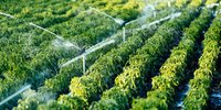
The term Anthropogenic Water Use (AWU) encompasses several water uses, but it is mainly represented by agricultural water allocated for irrigation purposes, which largely prevails on industrial and domestic water uses, thus representing a primary source of anthropogenic interference with the “natural” hydrological cycle. More than 70% of global freshwater withdrawals are attributable to irrigation; in some countries, the rates of water depletions linked to such practices reach up to 90% of the available freshwater (McDermid et al., 2023). Additionally, the impact of irrigation is expected to further increase in the next decades given the projected climate change scenarios associated with the foreseen population growth and consequent rising of food demand and living standards.
Objective
The overarching objective of Climate Change Initiative – Anthropogenic Water Use (CCI-AWU) precursor project is to derive long-term (at least over twenty years, since early 2000s) AWU time series for selected regions using several approaches exploiting remote sensing observations, as a proof-of-concept of the feasibility towards a proper AWU ECV product. In particular, AWU is more specifically intended as agricultural water allocated for irrigation, which represents the largest anthropogenic water use, thus making irrigation being the most impactful human activity on the hydrological cycle.
About the project
The monitoring of AWU dynamics has recently been enhanced through advancements in remote sensing technologies and Data Assimilation (DA) systems. Within this context, the CCI-AWU project aims to develop the AWU ECV by exploiting Earth Observations (EO) in the following ways:
- Creating coarse-scale/long-term (e.g., 20 years) AWU datasets for selected pilot locations (e.g., regional/basin scale) to advance understanding of human disturbances on land-atmosphere interaction processes.
- Assessing the capacity of coarse-scale (mainly microwave) EO data to inform irrigation retrieval algorithms and advanced land surface models for irrigation applications, thereby advancing the closure of the water cycle from a climate perspective.
- Developing tools and techniques to properly characterize the uncertainties associated with each AWU dataset. This includes validating AWU products against benchmark data and cross-comparing developed products to enhance uncertainty characterization.
- Utilizing AWU estimates to: (1) enhance agro-hydrological modeling and provide insights into water management practices, (2) facilitate closure of the water budget, and (3) conduct a comprehensive comparison between satellite-derived and model-derived AWU estimates.
Phase 1: Results
In the first phase of the project, experimental datasets of long-term (approximately 20 years), monthly-aggregated Irrigation Water Use (IWU) estimates - essentially considerable as total AWU estimates - at 0.25°resolution have been developed through different methodologies:
- The SM (Soil Moisture)-Inversion method (Dari et al.,2023).
- The SM-Delta method (Zappa et al., 2024).
- The Model-Observation Integration method.
Phase 2: CCI-AWU IMPRES (IMProved RESolution)
During phase 1, EO-based approaches have shown the capacity to represent large-scale irrigation dynamics and provide valuable regional information. However, further efforts are needed for the full exploitation of the products in operational or climate applications. The spatial resolution has been highlighted as a critical aspect in this regard. For this reason, in a second phase of the project medium to high resolution satellite retrievals will be exploited.
Regional datasets of long-term and coarse resolution irrigation estimates from space
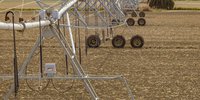
The products are experimental datasets of long-term (approximately 20 years) Irrigation Water Use at 0.25° resolution. They cover four regions: the Contiguous United States (CONUS), the Ebro River Basin in north-eastern Spain, the Murray-Darling Basin in south-eastern Australia, and India. They rely on three different methods: SM-based (Soil-Moisture-based) Inversion, SM-based Delta, and Model-Observation Integration, which is based on the Noah-Multiparameterization model.
The SM-based Inversion method was used to produce five datasets for the four regions, each using a different SM product as input. These include ESA CCI Combined, ESA CCI Passive, ASCAT (Advanced Scatterometer), SMOS (Soil Moisture and Ocean Salinity), and SMAP (Soil Moisture Active Passive).
The SM-based Delta method was used to produce six datasets for the four regions, each combining different SM and evapotranspiration (ET) products as input. The combinations include ESA CCI Combined SM & FLUXCOM ET, ESA CCI Passive SM & FLUXCOM ET, ESA CCI Active SM & FLUXCOM ET, ESA CCI Combined SM & SSEBOP ET, ESA CCI Passive SM & SSEBOP ET, and ESA CCI Active SM & SSEBOP ET.
The Model-Observation Integration method was applied to the CONUS and Murray-Darling Basin regions, producing three datasets using different irrigated surface maps as input. These maps include the Landsat-Derived Global Rainfed and Irrigated-Cropland Product (referred to as "Landsat", the Relative Bias Approach (referred to as "Method1"), and the Multi-Resolution Analysis Approach (referred to as "Method2").
The irrigation products are delivered with monthly temporal aggregation.
The datasets are available in Zenodo.
Below you will find the complete documentation relating to the ESA Climate Change Initiative's Total Anthropogenic Water use project
Phase 1
The ESA CCI-AWU team consists of leading scientists from 5 organisations in Europe. The project is led by Dr. Luca Brocca (National Research Council of Italy) and managed by Dr. Sara Modanesi (National Research Council of Italy).
- National Research Council of Italy, Research Institute for Geo-Hydrological Protection, CNR-IRPI
- Vienna University of Technology, TUWIEN
- University of Perugia, UNIPG
- Politecnico di Milano, POLIMI
- Katholieke Universiteit Leuven, KULeuven
Phase 2
The ESA CCI-AWU IMPRES team consists of leading scientists from 6 organisations in Europe. The project is led and managed by Dr. Jacopo Dari (University of Perugia).
- University of Perugia, UNIPG
- National Research Council of Italy, Research Institute for Geo-Hydrological Protection, CNR-IRPI
- Vienna University of Technology, TUWIEN
- Katholieke Universiteit Leuven, KULeuven
- Politecnico di Milano, POLIMI
- isardSAT


2026
Galli N, Capone F, Dari J, Chiarelli DD, Rulli MC, Albergel C, Saltalippi C, Morbidelli R, Brocca L (2026): Integrating biophysical models and remote sensing to evaluate irrigation practices in four global hubs. Under review in Agricultural Water Management.
Laluet P, Dari J, Busschaert L, Heyvaert D, De Lannoy G, Langhans P, Modanesi S, Massari C, Brocca L, Saltalippi C, Morbidelli R, Albergel C, Dorigo W (2026): Long-term irrigation water use datasets from multiple Earth Observation-based methods in major irrigated regions. Earth System Science Data Discussion [preprint]. https://doi.org/10.5194/essd-2025-737
2025
Dari J, Brocca L, Laluet P, Morbidelli R, Saltalippi C, Modanesi S, Dorigo W A, Albergel C (2025): Satellite-based estimates of irrigation water use versus modeling reconstructions: how much do they differ? ESS Open Archive [preprint]. 10.22541/essoar.176218923.33215210/v1
Laluet P, Corbari C, Baez-Villanueva O, Walther S, Zhang Y, Muñoz-Sabater J, Senay G. B, Albergel C, and Dorigo W (2025): Assessing the suitability of global evapotranspiration products over irrigated areas. EGUsphere [preprint]. https://doi.org/10.5194/egusphere-2025-5716
Modanesi S, Busschaert L, De Lannoy G, De Santis D, Natali M, Dari J, Quintana-Seguí P, Castelli M, Grasso, FM, Massari C (2025): Accounting for scaling effects on irrigation optimization within a land surface model using satellite observations. Journal of Hydrometeorology, e250057. https://doi.org/10.1175/JHM-D-25-0057.1
2024
Dari J, Morbidelli R, Quintana-Seguí, P and Brocca L (2024): The Temporal-Stability-Based Irrigation MAPping (TSIMAP) Method: A Virtuous Trade-Off between Accuracy, Flexibility, and Facility for End-Users. Water, Volume 16, Issue 5. https://www.mdpi.com/2073-4441/16/5/644
The following people can be contacted within the CCI-AWU project:
- Scientific Leader: Dr. Jacopo Dari (University of Perugia)
- ESA Technical Officer: Dr. Clement Albergel (ESA)